


")


軟體介紹
SkyDemon is one of Europe's most popular solutions for VFR flight planning and in-flight navigation.
Use this app to access your SkyDemon subscription on your Android device, unlocking SkyDemon's powerful features while on the move.
FLIGHT PLANNING FEATURES
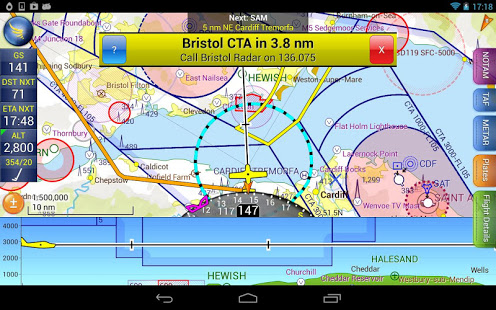
- SkyDemon vector charts are the clearest aeronautical charts you'll ever use, with dynamic airspace clipping and choice of map layers
- Route planning is as simple as touching consecutive waypoints and dragging to make changes
- Virtual Radar shows how your route relates to airspace, terrain, obstructions and other features
- Pilot Log facility calculates headings and groundspeeds from actual wind data, and shows useful frequencies
- Plates and other documents for relevant airfields are displayed automatically as you plan, and many are available georeferenced for use in flight
- Intuitive pan, pinch and rotate support with no loss of map clarity or text legibility
- File a VFR flightplan for your route directly to air traffic controllers
- Automatic TAF, METAR and SIGMET briefing as you plan a route, with graphical decoding
- Rainfall data can be overlaid on the main map, with animation, showing the trend of rainfall over time
- Integration of GAFOR route forecasts for Switzerland, Austria, Slovenia and Croatia
- Both narrow-route and area NOTAM briefings available, updated as you plan
- Advanced NOTAM graphical interpretation and depiction on the main map
- Easily print your PLOG and the output from various briefings
- Warnings for airspace and other potential hazards to your flight, updated in real time
- Airfield Admin Information shows useful contacts and other details for airfields featured in our charts
- Forecast winds aloft are automatically retrieved for the flight time and displayed on the map
- Create an advanced flight performance profile for each aircraft you use
- ATS Routes mode offers an alternative chart presentation for flight along airways
- Accurate fuel, weight and balance calculations including flight costings
- Create an unlimited number of user-defined waypoints
- Analyse your track logs for posterity
- Choose between six different vector chart styles
- Extensive European chart coverage as standard
GPS NAVIGATION FEATURES
- Intelligent warnings for approaching airspace, NOTAM, obstacles, terrain and other hazards
- Virtual Radar shows a side-on projection of all approaching features and how your trajectory relates to them
- Vector map automatically follows the aircraft in north up, track up or course up orientation
- Clear and concise instruments show you flight statistics and help keep you on track
- An HSI/ILS instrument helps you keep to your planned route and line up early for approach
- Live Pilot Log shows progress through your route, ETAs, ATAs and useful frequencies based on your current position
- TerrainSafe dynamically colours mountainous terrain around you to quickly identify safer areas
- Direct To allows easy re-routing in a hurry by picking from a selection of nearby airfields
- Approach Information shows runway diagrams, TAF, METAR, NOTAM and other airfield details useful for making an approach
- Live updates of TAF and METAR while in flight, with associated alerts*
- Extended runway centrelines appear automatically on the map as you near your destination airfield
- Permanent display of position relative to nearest well-known waypoint, for position reporting
- Easy changing of the planned route while in flight by touching and dragging
* Internet connection required for live weather update while in flight
Use this app to access your SkyDemon subscription on your Android device, unlocking SkyDemon's powerful features while on the move.
FLIGHT PLANNING FEATURES
- SkyDemon vector charts are the clearest aeronautical charts you'll ever use, with dynamic airspace clipping and choice of map layers
- Route planning is as simple as touching consecutive waypoints and dragging to make changes
- Virtual Radar shows how your route relates to airspace, terrain, obstructions and other features
- Pilot Log facility calculates headings and groundspeeds from actual wind data, and shows useful frequencies
- Plates and other documents for relevant airfields are displayed automatically as you plan, and many are available georeferenced for use in flight
- Intuitive pan, pinch and rotate support with no loss of map clarity or text legibility
- File a VFR flightplan for your route directly to air traffic controllers
- Automatic TAF, METAR and SIGMET briefing as you plan a route, with graphical decoding
- Rainfall data can be overlaid on the main map, with animation, showing the trend of rainfall over time
- Integration of GAFOR route forecasts for Switzerland, Austria, Slovenia and Croatia
- Both narrow-route and area NOTAM briefings available, updated as you plan
- Advanced NOTAM graphical interpretation and depiction on the main map
- Easily print your PLOG and the output from various briefings
- Warnings for airspace and other potential hazards to your flight, updated in real time
- Airfield Admin Information shows useful contacts and other details for airfields featured in our charts
- Forecast winds aloft are automatically retrieved for the flight time and displayed on the map
- Create an advanced flight performance profile for each aircraft you use
- ATS Routes mode offers an alternative chart presentation for flight along airways
- Accurate fuel, weight and balance calculations including flight costings
- Create an unlimited number of user-defined waypoints
- Analyse your track logs for posterity
- Choose between six different vector chart styles
- Extensive European chart coverage as standard
GPS NAVIGATION FEATURES
- Intelligent warnings for approaching airspace, NOTAM, obstacles, terrain and other hazards
- Virtual Radar shows a side-on projection of all approaching features and how your trajectory relates to them
- Vector map automatically follows the aircraft in north up, track up or course up orientation
- Clear and concise instruments show you flight statistics and help keep you on track
- An HSI/ILS instrument helps you keep to your planned route and line up early for approach
- Live Pilot Log shows progress through your route, ETAs, ATAs and useful frequencies based on your current position
- TerrainSafe dynamically colours mountainous terrain around you to quickly identify safer areas
- Direct To allows easy re-routing in a hurry by picking from a selection of nearby airfields
- Approach Information shows runway diagrams, TAF, METAR, NOTAM and other airfield details useful for making an approach
- Live updates of TAF and METAR while in flight, with associated alerts*
- Extended runway centrelines appear automatically on the map as you near your destination airfield
- Permanent display of position relative to nearest well-known waypoint, for position reporting
- Easy changing of the planned route while in flight by touching and dragging
* Internet connection required for live weather update while in flight
歷史版本
- 04/08/2021: SkyDemon 3.15.1
- 10/28/2020: SkyDemon 3.14.5
- Report a new version
- 軟體名稱: SkyDemon
- 軟體分類: 旅遊與地方資訊
- APK名稱: aero.skydemon.skydemonandroid
- 最新版本: 3.15.1
- 支持ROM: 4.1及更高版本
- 軟體大小 : 25.68 MB
- 更新日期: 2021-04-08
